UPDATED CRUME FAMILY INFORMATION
BY DIANE AND DEAN GLADOW
FEBRUARY 2010
Back to Crume page, Back to Williams page, Back to Stith Valley front page.
The information herein pertains to "Patriot" Philip D. Crume (born 9 August 1724, died 20 April 1801), his immediate descendants, and their land holdings in north-central Kentucky. Philip's grandson, Ralph Crume Jr., married Mary Lincoln, aunt of President Abraham Lincoln.
Although other researchers have attempted to attribute additional children to Ralph Jr. and Mary [Lincoln] Crume, census and court records clearly indicate there were only three-- Ralph Lincon Crume, William ("Dr. Billy") Crume, and Ann [Crume] Hoskinson.
A grandson of Ralph Jr. and Mary Lincoln Crume and son of "Dr. Billy", Silas Moses Crume (born 14 December 1825, died 23 March 1912) married Nancy Catherine Williams (b. 29 November 1831, d. 14 October 1876), daughter of John Finley Williams Sr. (b. 5 August 1797, d. 24 May 1848). Shortly after their marriage, Silas and Nancy became early settlers of southwestern Cherokee County TX. They, and several of their immediate descendants, are buried in Pleasant Grove cemetery, near Maydelle TX.
Table of Contents
I. "Updated Information About 'Crume Cemetery' This is an eleven-page document, including two pages of maps. The Crume family was related to President Lincoln (through his aunt Mary [Lincoln] Crume) and were early (1803) settlers of Breckinridge County, Kentucky. The document provides detailed information about the long-deserted cemetery, including a complete record of the land ownership from 1810 to the present, a brief history of the early Crume family, and probable burials in the cemetery, including Mary [Lincoln] Crume, and first cousins of the President.
II. Early Crume Land Holdings This four-page document primarily consists of maps, with one cover page of explanation. It involves the land holdings of Patriot Philip Crume in Nelson County, Kentucky; which were deeded to him for service in the Revolutionary War (with one deed signed by Patrick Henry). Philip was father and grandfather of the Breckinridge Crumes discussed above.
January-February 2010
UPDATED INFORMATION ABOUT "CRUME CEMETERY"
Including land records working backwards from present day and "intelligent guessing" about the burials therein, including relatives of President Abraham Lincoln
The Cemetery
In Breckinridge County KY, at a location 0.23 miles north and 180 yards west of "Fairfield corner" (Highway 690 and the Hudson/Fairfield/Buras road), lies what almost certainly has been a previously deserted cemetery. The geographical coordinates are 37 degrees, 40.458 minutes North Latitude and 86 degrees, 17.326 minutes West Longitude. See map on next page. As of 2009, this location was found to be a somewhat raised mound, roughly 60 feet long (north-south) and 35 feet wide (east-west) of grass, weeds, brush, and a rather large tree stump surrounded by a corn field. It would seem this is where several members of the early Breckinridge County Crume family are buried. Most of these Crumes, some of whom are direct ancestors of Diane Gladow, were also relatives of President Abraham Lincoln. Despite the efforts of several current-day genealogy researchers, these Crume graves could not previously be located. Although there are no conventional (i.e., modern-day) headstones present, the evidence that this is indeed the "Crume Cemetery" includes the following:
A. A letter written in 1960 by Eva M. Silvens of Sarasota FL, another descendant of the Breckinridge Crumes, includes the following: "Dr. Wm. (Billy) is buried at FAIRFIELD, KY. near East View, Ky., I have heard my mother say, and at times I have asked her to go with me to see if we could locate their graves, but she said she thot [thought?] it too long since and 'could not be sure', so we never tried (her health was poor-- a cancer)." [Note: "Dr. Billy" Crume was the son of Ralph Crume Jr., who married Mary Lincoln, aunt of the President. Although East View is not the closest town to Fairfield corner- lying about 20 miles to the southeast, it probably was familiar to Eva's mother, since some of the family-- including her uncle Ralph Marks Crume, son of "Dr. Billy"-- lived at East View for a time after the Civil War.]
B. As can be seen from the map, the tree stump and a couple of smaller evergreen trees are in a line which would seem to be at the head ends of the graves, thus indicating that they were purposely planted on the site.
C. From the information available to us earlier in 2009- including known burial location of Ralph Marks Crume (Fairview Methodist Church cemetery), an early map sent to Diane's mother (probably in the 1960s), a few of the early Crume land transactions from Breckinridge deed books, and "word of mouth" information gathered during our 2006 visit to the area- the location of early Crume land holdings (starting in 1803) was narrowed down to an approximate four by five mile area in southeastern Breckinridge County. This area included Fairfield corner.
D. Primarily by the use of a 1963 U.S. Geological Service map of this area, it was found that there were (a somewhat astounding) 26 known cemeteries within the "narrowed-down" area. Communication with the Breckinridge Archives-- both in early 2009 and during our later visit in that all 26 of these have been identified, visited, and all legible gravestones have been read and recorded. The only Crume grave in any of these 26 was the already known location of Ralph Marks Crume. (Although not having the Crume surname, Ralph Marks' sister, Susan Mary [Crume] Tucker and husband John Berry Tucker are also at Fairview Methodist.)
E. However, this communication (including that of John Lay, Elizabethtown Lincoln researcher who was helping with this quest) with the Breckinridge Archives resulted in a breakthrough. Shirley Pile-- who has worked part-time with the Archives, is also a descendant of the early Crumes (via Ralph Crume Jr.'s sister, Rachel [Crume] Lucas), and has always lived in the general area of interest-- indicated that she had heard (from grandparents when she was young?) that there was an unkempt cemetery site near Fairfield corner which was known as "Crume cemetery". In a follow-up phone conversation, she said that as passed on to her, "the Crumes buried there were related to President Lincoln". She provided information about the general location-- in a field northwest of Fairfield corner. The reason that the cemetery was not among the ones which have been cataloged is that there were no legible gravestones present.
F. When John Lay, and his friend Henry Morrison, attempted to locate the cemetery site, they were initially unsuccessful. Fortunately, during their visit they ran into the current land owner, Philip Hudson, also of Elizabethtown. He showed them the correct location and independently volunteered that his grandfather and father (previous owners of the land) had passed on to him that "the people buried there were related to President Lincoln".
G. Mr. Henry Morrison has successfully "dowsed" for graves many times in the past. He, prior to running into Mr. Hudson, had attempted to dowse a site which John Lay thought might be the cemetery, and reported to John there were no graves present. After being directed to the correct site by Mr. Hudson, he repeated his dowsing (despite the presence of weeds and brush) and reported that thirteen people ("five males and eight females") were present.
H. During our October visit, Mr. Morrison (several months after his earlier visit and after John Lay, with the help of a younger friend, had done some clearing of the site, repeated his dowsing in our presence, and exactly repeated his earlier conclusions, with the added information that one of the graves was that of a male child. Using wire-type surveyor stakes, both ends of all thirteen graves were marked as located by him. (In addition, larger wooden stakes were driven into the "corners" of the cemetery, and measurements were made from southeast corner to the stump and a nearby electric service pole. See map of the cemetery)
I. Using probes, we were able to locate -- at the ends of the grave-sites identified by
Mr. Morrison -- four shallowly-buried field stones which we believe were meant to mark the
graves. These were dug out. The largest stone-- perhaps 75 pounds, about four inches
thick, and flat on both sides-- is at grave #8 (partially overlapping grave #7), and
appears to have "R. C." scratched into it. The second largest stone (grave #1)
also appears to have some scratchings. It is possible that additional stones had been
moved from the cemetery, perhaps to the location first looked at by Lay and Morrison,
since a pile of rock was present there. (Due to inclement weather and a shortage of time,
we did not attempt to examine these.)
Land Ownership
Let us now move on to the current and previous ownership of the land on which this cemetery site lies. Identifying and tracing this land back proved to be rather difficult and required several days of work at the Breckinridge courthouse, even with the assistance of Archives personnel, since Kentucky uses the "metes and bounds" system (e.g., "starting at 3 post oaks in Smith's line, thence S 47 W 60 poles to large rock"), and the early deeds in Breckinridge County typically have very little (excepting general area) reference to roads or streams, and normally do not include maps.
1. As mentioned above, the cemetery land has been in the ownership of Philip Hudson, his father, and grandfather, L.H. Hudson, since 1949. Philip provided us with two aerial maps on which he outlined the land which he currently owns. From information on these aerial views, his holdings include 31.5 acres to the northwest of Fairfield corner (containing the cemetery site), 127.5 acres to the northeast, and 101.6 acres to the southeast. Since he indicated that he had a "total of 300 acres", we assume he owns an additional 39 acres (approx.) which he did not have included in the outline.
2. Per Breckinridge Deed Book 93, page 58, 40 acres was transferred to L.H. Hudson from Silas Hudson on 15 November 1949. From its description, this would be the 31.5 acres currently owned by Philip to the northwest of Fairfield corner plus 8.8 acres immediately adjacent to the corner (also to the northwest) which includes some buildings (house, barn, and what was formerly the "Fairfield store") which Philip indicated was, or had been, owned by his aunt.
3. Per Breckinridge Deed Book 79, page 383, (and referenced by the above), this 40 acres (same description) was transferred, on 5 November 1938, to Silas Hudson from Wilbur & Thelma Sharp, Carrie [Sharp] & Clyde Quiggans, Lillie [Sharp] & Wilbur Condor, and Roy & Addie Sharp-- all of whom were heirs of R.C. Sharp.
4. Per Breckinridge Deed Book 58, page 632, (and referenced by the above), the 40 acres (same description) was transferred, on 18 April 1908, to R.C. Sharp from J.H. Dobson.
5. Per Breckinridge Deed Book 55, pages 377-378, (and referenced by the above), J.H. Dodson, on 1 November 1898, obtained this 40 acres, and additional, from Geo. W. Neff, administrator for G.P. Duncan (deceased). Unfortunately, the description of the land is incomplete, and acreage is not provided. However, some boundary information is given, and from it, this land consists of the same 40 acres plus an additional tract on its northern side. Interestingly, the boundary description starts: "Beginning at a stone, J.N. Dodson's corner at the end of a lane near the Fairfield school house....". (See next paragraph.)
6. Per Breckinridge Deed Book 40, pages 237-238, George P. Duncan obtained 122 ˝ acres (with one acre thereof reserved by the grantors) from Ralph M. [Marks] and Mary T. Crume on 27 July 1886. This tract is rather well-defined by the description within the deed (although the boundary does fail to close), which includes nine boundary segments. It is a rather narrow piece of land (mostly less than 300 yards wide, east to west, but roughly a mile in length, north to south). The one acre which was reserved, described in the first deed as "adjoining John Scott's fence near the sign board by the dripping spring", was evidently deeded two weeks later (11 August 1886) by the Crumes to Breckinridge School District #87, per Breckinridge Deed Book 40, page 607. In the latter deed, the description of the one acre is more concise--- "beginning at Joseph Dobson's corner near the big road, running due W 40 yards to a stone, thence S 88 yards to a stone, thence East 60 yards to another stone in John Scott line, thence his line to the beginning". These two transactions certainly indicate this 122 ˝ acre tract included the "Crume Cemetery", because:
a. Some of the boundary segments and corners used in the deed of #5 above were repeated for this 122 ˝ acres, including "N9W", "black oak" (corner 1), "100 poles", "stone near a white oak" (corner 2), "N75W 30 poles", and "white oak" (corner 3).
b. As explained to us by personnel at Breckinridge Archives, the "sign board" is a locally recognized terminology for a road intersection. In this case, it almost certainly is the intersection of what is now Highway 690 and the Hudson/Fairfield/Buras road, and known to us as "Fairfield corner".
c. The one acre deeded to District #87 is almost certainly the land on the southwest corner of the current intersection. The dimensions in the deed are roughly the same as defined by the current fences on this corner. The one building on this land was originally a one-room school, but it is now Fairfield Holiness Church. Shirley Pile (see paragraph "D" above) attended this school as a child in the 1940s. [Note: In the deed, it was stated that the one acre should be used for either a school or a church.]
d. The description of boundaries includes references to neighboring land owners-- "Richardson", "Dobson", "Scott", "Thurman", "Hardin", and (on the west side) "Crume". These are all familiar names from other Breckinridge documents, including deeds and land transactions in this specific area.
e. In several early Breckinridge documents pertaining to the Crume family, we have found repeated references to "big road", "state road", and/or "Crume valley and Hardinsburg road ". It's almost certain that this is the road now known as "Fairfield/ Buras" (despite present-day Hwy 690 being wider and more traveled).
f. The map made from the description of the 122 ˝ acres, combined with the map of an adjoining 26 acre tract (Thomas S. & Annie Dodson to Lee H. Hudson, 3 November 1904, Breckinridge Deed Book 56, page 205), when made to the same scale as, and overlaid on, the aerial photographs supplied by Philip Hudson (item #1, above), reveal multiple boundaries and corners which match with current-day features. These include-- boundary on northern 2/3 of eastern side of the 122 ˝ acres very nearly corresponds to present-day Fairfield/Buras road, northeastern corner location and boundary segment orientation corresponds to a land ownership division line (0.8 miles north of Fairfield corner), northwestern boundary segments correspond to land ownership lines, southern end is adjacent to a short length of Clear Prong of Calameases Creek (and "dripping spring"?), northern corners of 26 acres correspond to "small branch [creek] in Dodson's line" and "stone, west side of the big road", etc.
7. Per Breckinridge Deed Book 31, pages 78-79, Ralph M. Crume obtained this same 122 ˝ acres from his parents, William ("Dr. Billy") and Mary Ann Crume, on 22 September 1875. {Note: The Crume names are misspelled as "Comes" and "Come" in this document, but lines for signatures have correct spelling. Mary Ann [Lucas] Crume was Dr. Billy's second wife; Diane Gladow is a descendant of Dr. Billy and his first wife, Mary Susannah {Hoskinson} Crume.}
8. Per Breckinridge Deed Book T, page 248, this same 122 ˝ acres was transferred to William Crume from Philip Thurman on 11 March 1851. Interestingly, exactly the same land description was used as in the above two deeds (in 1875 and 1886)-- excepting the "one acre reserved" in the latter document. Therefore, the references to neighboring land ownership were undoubtedly valid in 1851, but somewhat doubtful when the land was sold out of the Crume family in 1886. As indicated by paragraph "A" on the first page, William ("Dr. Billy") Cox Crume is almost certainly among those buried in "Crume Cemetery". However, it seems evident that most of the other graves are of Crume family members who died earlier (see final section of this write-up). Therefore, it seems that Dr. Billy's (re-)purchase of this 122 ˝ acres in 1851 was to secure a piece of the early Crume land holdings, including the family cemetery. He was the son of Ralph Crume Jr. (& Mary [Lincoln] Crume) and the grandson of Ralph Crume Sr., the patriarch of the Breckinridge Crumes.
9. Per Breckinridge Deed Book N, page 461, Philip Thurman purchased two tracts totaling 510 acres, which included the above 122 ˝ acres, from the Marks family on 16 October 1843. Ann (or Anna) [Barrett] Crume Marks Morris was the step-mother of Ralph Crume Sr., and her four children by her second husband Jacob Marks were his step-siblings. See the following section for more detail about the Crume/Marks relationship and the relative location of their land holdings in Breckinridge County.
Crume/Marks Relationship and Land Ownership
"Patriot" Philip Crume, the father of Ralph Crume Sr., spent most of his life in the Shenandoah Valley of Virginia before moving his large family, about 1790, to Nelson County KY, where he had been awarded 1200 acres for his service during the Revolutionary War. He had fathered twelve children, including Ralph Sr., by his first wife, Sarah Margaret [Weathers (or Withers)] Crume. After her death, Philip re-married a much younger woman, Ann Barrett, and fathered five more children by her.
After Philip's death, Ann married Jacob Marks in Nelson County in 1804. By 1812, she had produced four additional children by him, and the family had moved to Breckinridge County onto land adjacent to that of the Crumes. 450 acres of their Breckinridge land had evidently been purchased, via bond, in 1810 from William Buford but was not recorded until 8 December 1818 (Deed Book D, pages 377-378). Meanwhile, Jacob had died, apparently rather suddenly, in 1814. Therefore, this tract was transferred to his heirs-- Ann and the four children. Since the family had only been in Breckinridge for a short time, and land ownership may still have been in limbo, we speculate that Jacob was probably buried in Poplar Flat cemetery in Nelson County. This is where Ann was eventually buried (35 years later) and where her Philip, her first husband was buried. There are several other Marks in that cemetery, and there is an unmarked field stone adjacent to Ann's grave.
Ann evidently decided to stay in Breckinridge County. On 23 October 1819, she purchased an additional 60 acres (Deed Book E, pages 59-60) from Moses Ragan, this time in her name only. >From the description, this 60 acres adjoined the 450 acres already owned by the family. See map on next page. Sometime within the next year, she married a third time, to William Morris.
How do we know that the two tracts owned by the Marks family were adjacent to Crume land? In January of 1810, Ralph Crume Sr. and three of his children--- Ralph Jr., Charles, and Levi Horsley (husband of daughter Sarah)-- purchased six tracts of land from John Fentress. When mapped out per the land descriptions, four of the Crume tracts (and perhaps the other two as well) fall into a pattern which not only fit together, but also have the same eastern and western boundary directions (21 degrees off of north-south on the eastern side and 15 degrees off of north-south on the western side). The Marks' 450 acres has these same directions on the east and west side boundaries, and the upper (northern) corner descriptions match with the southern edge of the Crume holdings. Ralph Sr.'s previously purchased tract of 120 acres is immediately adjacent to the Marks' tract. See map on next page.
In 1827, a daughter of Ann, Elizabeth Marks, died at age 17 (24 October 1827) in Breckinridge County. We believe that Elizabeth was probably the first person to be buried in "Crume Cemetery". Via additional mapping of the land descriptions and overlay on the previously described holdings, it appears that, almost certainly, the cemetery was on the 60 acres which Ann purchased for herself in 1819. See map on next page.
The Crume "patriarch" of Breckinridge County was Ralph Crume Sr. (1750 - 1829). He, son Ralph Crume Jr. (who married Mary Lincoln, the aunt of the President), and other of his children made significant purchases of Breckinridge land starting in 1803. At this point, we have collected a total of over 60 Crume land transactions in Breckinridge County prior to the start of the Civil War in 1860. There are also several transactions for Crume "daughter descendants" having a different surname -- including Lucas, Pile, Tucker, Marks, Horsley, Basham, Hudson, and Drane. At one point (1820s), it appears that Ralph Sr. and his children owned more than 1500 acres (2 ˝ square miles). In fact, at least one document has Ralph Sr. referring to "my plantation". Most of the Crume land transactions refer to "waters of the Calameases" (with a number of different spelling variations), a large stream and several tributaries thereof in the vicinity of Fairfield corner, and a few refer to "waters of Rough River". Some of the early documents refer to "Crume Valley", which was in the area of Fairfield corner, and/or immediately to the north and west thereof. The map shows only those tracts pertinent to this discussion.
Crume Valley Map Explanation
The map on the following page shows early Crume family land holdings pertinent to this write-up. The land boundaries are overlaid on a portion of a USGS contour map (Custer KY, TKY0158). These maps are more accurate than the normal road maps, particularly for location of creeks and streams.
Fairfield, or Fairfield corner, is located at the bottom center (on Hwy 690) and Buras is at the upper left, with the Fairfield/Buras road going between the two, and essentially through the middle of the Crume land holdings, which apparently (and along with additional tracts) were known as "Crume Valley". The Clear Prong of Calamese Creek is below Fairfield and the North Fork of Rough River is above Buras.
Crume Cemetery is located at the cross mark about a half-inch above Fairfield. As can be seen, it would have been located in Ann's 60 acres. Although not shown on this map, Dr. Billy's 122 ˝ acres would have essentially encompassed this 60 acre tract and included additional acreage to the north, within the Marks' 450 acres. Also not shown on this map was another Crume land holding to the west (left) of Fairfield, which was eventually deeded (2 Feb 1886, Deed book 41, pages 482-483) by Crume descendants to the Elliot family, who evidently started the Elliot cemetery shown on the map.
As indicated in the previous section, the 510 total acres owned by Ralph Sr.'s step-mother and her second family adjoined one of his own tracts (which probably included his home). His tract, the three others shown above it, and a couple more not shown, were all purchased from John Fentress in January of 1810 (Deed book C, pages 22-26). The other three shown were deeded to Ralph Sr.'s sons, Ralph Jr. and Charles.
People Buried in Crume Cemetery
At this time, it is impossible to be certain about the identities of those buried in the cemetery, since no legible gravestones have been found. Hopefully, some legible stones may be found later (in the pile mentioned above?), and/or additional documents will turn up which include the burial information for specific individuals.
However, some "intelligent guessing", based on the process of elimination, can be pursued. We know the time period of interest, and at least approximate death dates of most of the early "Breckinridge Crumes". We also know of some who were buried elsewhere, and/or had moved far away, with small likelihood of their bodies being returned (prior to the advent of trains and automobiles in Breckinridge). If we accept the dowsing results of Mr. Henry Morrison (paragraph "G" on page 3), which seems to be repeatable and rather specific, there are eight females and five males (including one male child) present.
Actually, the first Crume to die in Breckinridge County appears to be either William W. Crume (born 1783, died 1812) or his wife, Susannah "Luvernia" [Jones] Crume (b. 1784, d. 1812?). William and his young family are shown in the Breckinridge census of 1810, and he had purchased 100 acres on 12 March 1810. On the other hand, it can be argued that the Crume "clan" may not have been completely settled down by the time of his death and ready to start the cemetery, and that is our present assumption. Although original Crume land holdings were obtained in 1803, other significant purchases were made starting in 1810, and the original holdings were sold in that following time period. Luvernia's death date is unknown, but most likely occurred sometime prior to the 23 August 1813 transfer of 160 acres between Robert Kincheloe and "heirs of William Crume", which listed the four children but not the wife. There is also a document which shows that Ralph Crume Jr. was appointed guardian of the children. She and William had been married in Breckinridge County in 1805, and there were at least two Jones families living there at the time of 1810 census. We speculate that she, and husband William, may have been buried together on the Jones land holdings, particularly if she died first.
Our "best guesses" for the people in the Crume Cemetery include:
Elizabeth Marks (b. 17 Aug 1810, d. 24 Oct 1827)-- See discussion in previous section.
Ralph Crume Sr. (b. 1750, d. 1829)-- The patriarch of the Breckinridge Crumes seemingly did not leave a will, and the final settlement of his estate drug on to 1842. It seems likely that he was an early burial in the Crume cemetery.
Mary "Polly" [Riggs] Crume (wife of Ralph Sr., b. Bet. 1750 & 1759, d. Bef. May 1839)-- Her exact death date is unknown, but she did outlive her husband.
Ralph Crume Jr. (b. 1779, d. Bet. 1830 & 1832)-- Some have speculated that Ralph Jr. died and was buried in Vermillion County IN, because they are shown as being there in the 1830 census. However, this was most likely of short duration (possibly just a visit to their children?), since he never owned land in Indiana. (The acreage which appears in the Vermillion records was deeded to his son, Ralph Lincoln Crume.) No record of Ralph Jr.'s death or burial can be found in IN.
Mary [Lincoln] Crume (aunt of the President and wife of Ralph Jr., b. Bet. 1775 & 1777, d. Bet. 1830 & 1832?)-- Again, death year is uncertain, but a 18 October 1832 Breckinridge Chancery Court ruling does not list Mary as being among the heirs of Ralph Jr. Others have said that Mary died and was buried in Vermillion County IN (probably because of the census), but no evidence of this has surfaced. Other reports have her being buried at Mill Creek cemetery in Fort Knox KY, but that person is Mary [Brumfield] Crume, daughter-in-law of Mary [Lincoln] Crume and first wife of Ralph Lincoln Crume.
Rachel [Crume] Lucas (daughter of Ralph Sr., and wife of Benedict Lucas Sr., b. 1773, d. Aft. 1850)-- The Lucas family became rather prominent land holders in Breckinridge County, and seemingly would have had headstones and perhaps buried on their own land, but Rachel and her husband have not been found elsewhere.
Benedict Lucas Sr. (husband of Rachel [Crume] Lucas, b. 1774, d. 1838)-- Benedict did leave a will, but provided no instructions concerning his burial, and his grave has not been found elsewhere. His land holdings were in the same area as the Crumes, and his relatively early death may have prompted his burial in their cemetery.
Ann [Crume] Hoskinson (b. Abt. 1805, d. ?)-- Ann was one of only three children of Ralph Jr. and Mary [Lincoln] Crume--- William Cox Crume and Ralph Lincoln Crume being the other two, as is clearly shown by both census data and court records pertaining to being heirs of their father and grandfather Crume. Ann and husband Charles Hoskinson were in Vermillion County IN in 1830, and likely stayed there until at least 1836 when they sold the land which had been purchased from Ann's brother, Ralph Lincoln Crume. Thereafter, their presence is only noted in sporadic references, and they have not been positively identified in later census data, nor have their two known daughters.
Charles Hoskinson (husband of Ann [Crume] Hoskinson, b. Bet. 1800-1810, d. ?)-- Charles is mentioned in his father's estate settlement (1855, Hardin County KY), indicating that he was perhaps still living. Other than that, we've found nothing past 1836.
William Cox Crume (b. 1804, d. Aft. 1883)-- As discussed in earlier sections (particularly paragraph "A" on first page), it seems almost definite that "Dr. Billy" is buried in the cemetery. His (re-)purchase of the 122 ˝ acres containing it may well have been prompted because those already buried there included his first wife; see paragraph below. His exact burial location may well be "1" on the enclosed map, since he was quite likely the last to buried there (with possible exception of his second wife).
Mary Susannah [Hoskinson] Crume (first wife of Dr. Billy, b. ?, d. Bet. 1830 & 1837)-- Once again, exact death date is unknown. She, Dr. Billy, and their young family were living in Vermillion County IN in 1830, and others have speculated that she died there. However, we cannot find any notice of her death or burial there, and Dr. Billy had returned to Kentucky sometime previous to his second marriage in 1837.
James F. Crume (son of Dr. Billy and second wife Mary Ann, b. Bet. 1845 & 1846, d. 1852)-- It seems likely that James is the male child buried in location "3", particularly since the cemetery land was in the possession of Dr. Billy when this son died.
Mary Ann [Lucas] Crume (second wife of Dr. Billy, b. Abt. 1805, d. Aft. 1883)-- It seems likely that Mary Ann is buried in location "2".
As can be noted, the above list does total to 13 (but has 6 males, 7 females). However, there are other, but less likely, candidates. These include Silas Crume (possible eighth child of Ralph Sr.), Ralph Lincoln Crume (son of Ralph Jr. and Mary [Lincoln] Crume] and his second wife, Rebecca Jane [Carr] Crume, Sarah "Sally" [Crume] Horsley (daughter of Ralph Crume Sr.) and husband Levi Horsley, and Ann Crume (daughter of Dr. Billy and Susannah Crume) who died as a child.
Any corrections and/or additions to any of the above would be welcomed!
--Dean & Diane Gladow--
1748 Yucca Lane, Emporia, Kansas 66801
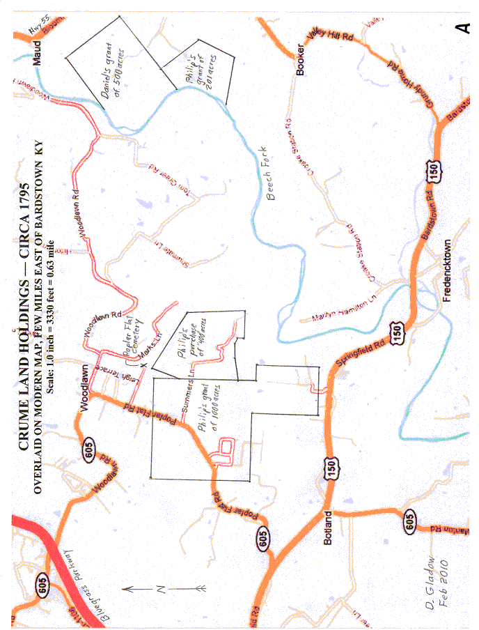
EARLY CRUME LAND HOLDINGS
BARDSTOWN AREA, KENTUCKY
As compiled by Dean & Diane Gladow, with much information provided by Lucy Geoghegan
"Patriot" Philip Crume spent most of his life in the Shenandoah Valley of Virginia before moving his large family, about 1790, to Nelson County KY, where he had been awarded 1200 acres for his service during the Revolutionary War. He had fathered twelve children by his first wife, Sarah [Weathers (or Withers)] Crume. After her death, Philip re-married a much younger woman, Ann (or Anna) Barrett, and fathered five more children by her.
One of Philip's sons, Daniel, was also granted land (500 acres) in the same area. Although present-day descendants of the Crumes knew in general where the Crume land was located, no one- to our knowledge- had ever fully mapped it out to determine exact position, probably due to the difficulties of interpreting the metes and bounds system of surveying (e.g., "starting at two beech trees in Smith's line, thence S 20 E, 43 poles to large rock"). Using about 20 of the early deeds (most of which were supplied by Lucy Geoghegan), we finally pieced together enough of the landmarks to determine where the land actually is relative to more recent maps.
Attached map "A" shows the Crume tracts overlaid on a modern map. To provide orientation, the dark red road at the upper left is the Bluegrass Parkway passing by the southeast side of Bardstown, Kentucky. An exit (not shown), provides access to U.S. Highway #150, which eventually leads to Springfield and Lincoln Homestead State Park. However, about 2 ˝ miles east of the Parkway on Hwy. 150 is State Road #605, known to locals as "Poplar Flat" road. As can be seen, this- and smaller dirt roads- provides access to what was originally Crume property. Philip was, on 2 December 1785, granted 1000 acres; the deed, or "patent", was signed by (the "give me liberty or give me death") Patrick Henry! On 8 March 1796, Philip purchased an adjoining tract thought to contain 400 acres, but later re-surveyed to 362 acres. Upon his death in 1801, Philip was buried in Poplar Flat cemetery, just to the north of these two tracts.
Map "A" also shows two other tracts-- another 201 acres granted to Philip on 18 May 1790 and the 500 acres granted to son Daniel (perhaps a bit earlier). These two tracts were adjoining and lay on the banks of the Beech Fork (tributary of the Salt River). Beech Fork is the dividing line between Nelson and Washington Counties.
Map "B" shows the Nelson County tracts overlaid on a much earlier (1882) map from an atlas. Note at that time, the roads were a bit different and Poplar Flat cemetery had an adjacent church and school. Actually, by that date, the early Crume tracts had been subdivided and much of the land had been sold. However, it is interesting to note the houses of several Crume descendants (as well as several Beams, perhaps associated with the bourbon?).
In 1797, Philip-- via power of attorney-- directed his eldest son, Ralph Crume Sr., and a neighbor, Richard Parker, to divide up his two grants totaling 1201 acres, with the majority of the land going to his children from his first marriage and four tracts to Mr. Parker. (His second wife, Ann, and the two sons from that marriage later received a division of the purchased "400 acres".) Map "C" shows how the 1000 acre tract was divided. Note that granddaughter Rachel [Crume] Lucas (eldest child of Ralph Sr. and wife of Benedict Lucas) also received a tract. Somehow (perhaps using a short "pole" for their surveying?), the two attorneys-in-fact managed to distribute a total of 1076 acres out of the original 1000! In any case, map "C" does show what they intended for the division. One child, daughter Mary [Crume]
Birkhead, received a tract of 85 acres from the 201 acre grant on Beech Fork.
--Please provide any additions and corrections to Dean & Diane Gladow, 1748 Yucca Lane, Emporia KS 66801-